Develop empirical tools for predicting the potential decomposability of carbon stored in permafrost-region soils

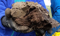
Soil organic matter (SOM) in permafrost regions is often preserved by cold temperatures in a relatively undecomposed state both in surface horizons and in buried forms (e.g., peat deposits, cryoturbated organic matter; Figure 1). In addition, much of the region's SOM is uncomplexed or only poorly associated with soil minerals.
To characterize the potential decomposability of the region's SOM, we are developing tools that are based on a robust set of indicators obtained from the multivariate interpretation and synthesis of infrared spectroscopy databases. Our aim is to provide large-scale models with estimates of the intrinsic decomposability of organic matter stored in permafrost-region soils to aide in reducing uncertainty and support model calibration and validation.
Generation of indicator data

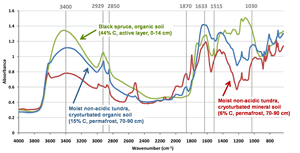
We are using infrared spectroscopy — diffuse reflectance Fourier-transform mid infrared spectroscopy (MidIR) — to provide information on a variety of soil properties. MidIR spectra (Figure 2) contain information about many important organic functional groups, such as labile fatty acids, proteins, and carbohydrates, as well as more degraded or refractory forms, such as “humified” material or black carbon. Besides organic features, MidIR spectra contain information about minerals such as clays, carbonates, and silicates, which also provide relevant information for predicting potential decomposability.
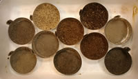
Generation of MidIR spectra is rapid and non-destructive, and it can be accomplished with relatively small samples. Thus, we are scanning large numbers of SFA-collected and collaborator-contributed soils to build an extensive infrared spectroscopy database representing a broad range of soil types and horizons from different land cover types and bioclimatic zones throughout the northern circumpolar permafrost-region (Figure 3; to get involved in this effort see text box below). This database, together with applicable metadata, will ensure that selected indicators of decomposability are applicable across the region and enable geospatial modeling and mapping of this information.
Generation of tools for assessing intrinsic SOM decomposability
At present, we are exploring several approaches for assessing the relative degradation state of permafrost-region SOM that are based on interpretation and calibration of MidIR spectra. We are identifying biogeochemical indicators that reflect differences in the genesis and past history of organic matter degradation before its stabilization in permafrost. By integrating selected indicators, we envision development of a “relative degradation index” (RDI), which will provide a qualitative ranking system for representing the intrinsic degradation state of SOM, i.e. the amount of decomposition it has already undergone. We are investigating a variety of potential indicators — including ratios of MidIR spectral bands characteristic of specific organic compound classes, organic-to-mineral band ratios, and calibration of MidIR spectra to predict conventional measures of biologically active or labile SOM (e.g., easily extractable C, particulate organic matter, light fraction).
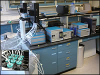
The efficacy and reliability of these indicators will be evaluated against soil incubation experiments (Figure 4). Ultimately, the RDI ranking system will integrate a set of indicators that best define the intrinsic degradation state for the widest possible range of soils. The predictive capability of the RDI product will be validated against additional incubation data. We expect the RDI to be applicable across gradients of climate, vegetation type, soil type, and horizon type within the permafrost region. By coupling the RDI with the maps of soil organic C stocks generated under Objective 1, we intend to conduct geospatial analyses to predict potentially vulnerable soil C stocks. In addition, we expect the RDI product, particularly after geospatial extrapolation, to be used for qualitative evaluation of Earth-system and regional-scale model calibrations and for model validation.
Contribute to the Permafrost-Region Soil Spectroscopy Database (PermafrostIR)
If you study permafrost-region soils, we need your help in building the “PermafrostIR” database that will be used to map the quality of soil organic matter across the permafrost-region. It is easy to get involved: 1) contact us and tell us about your samples, 2) send us your samples along with relevant metadata, 3) we will scan your samples and send you the Mid-IR spectra for FREE, and 4) the data will be added to the database with attribution to you as the source of the samples and metadata. This benefits you by providing free infrared spectra for your research, and you will be contributing to thousands of other spectra. We benefit by obtaining spectra from samples we could not afford to collect otherwise to meet our objectives, as well as by increasing consistency of database spectra through use of the same instruments and protocols.


